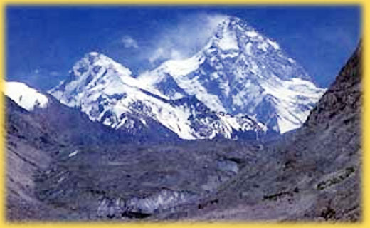
ˇ°Qogriˇ±,
in Tajik language, means ˇ° tall and magnifi-centˇ±. The main peaks
of Karakorum mountain range, Because of its altitude of 8611 meters,
Qogri is also the second highest peak in the world, which named
K2 Peak abroad.At 76.5ˇăE
and 35.9ˇăN, K2Peak is located in the middle section of Karakorum
mountains, the part of which in China is in Yecheng county.
Karakorum
mountains, over 6000 meters above sea level, stretches long and
unbroken for several thousands kilometers, running northwest-southeast.
With high peaks (including K2 Peak) clustering in the mountain
range, there are four peaks of the world level over 8000 meters
in height which are linked together. On the east side of K2 (Qogri)
Peak, is Brown Peak (8051 meters). Successive in order is Gasherbrum
I Peak of 8080 meters, while Gasher-brum II Peak stands 8034 meters
above sea level. The peaks here take about one third of the 14
high peaks over 8000 meters above sea level in the world. Besides,
more than 20 peaks reach over 7000 meters, for example, Sikeyang
Kainli Peak on the north side (7545 meters), Sipande Peak (7385
meters) on the west side and Crown Peak at 7295 meters, thus making
it the second center for mountain climbing and the focus of the
mountaineersˇŻ attention. K2 (Qogri) Peak id made up six mountain
ranges, among which the northwest-southeast mountain range acts
as the main ridge line of Karakorum mo-untains range as well as
the boundary between China and Pakistan. In addition, there are
the North ridge, the West ridge, the Northwest ridge, the Southwest
ridge, the summit of which are Pyramid-shaped and full of steeply-rising
snow cliffs and has the dangerously steep lie of the mountains.
On the slope walls scatter the traces of chutes caused by snow
avalanches. On the top of the peak, a snow slope goes gently to
heights from the North to the South and extends over a large area.
The North side of the snow slope is an average of over 45 degrees,
looking just as if being cut by a knife and spitted by an axe.
The vertical height difference between the base camp site in the
north to the summit reaches even more than 4700 meters, making
it the highest peak over 8000 meters with the greatest vertical
height difference in the world. In the lies K2 (Qogri) Glaciers
with its complicated and changeable terrain, the tattered surface
of the glacier and the cress-crossing open and hidden crevasses.
The steep rock walls or cliffs in the valley west of the glacier
are frequented by rolling rocks, ice avalanches and snow avalanches.
The Yinsugaidi Glacier, which amounts to 44 kilo-meters, is right
on bothsides of K2 (Qogri) Peak
Not
only has K2 (Qogri) Peak characteristics of 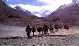 dangerous
and perilous trrain but also the extremely harsh weather. The
rainy season of this area is in May and lasts till Sep-tember
every year, when the warm and wet air current of Southwesterly
monsoon is covered into rainfall. From mid-September to mid-April
of the next, the powerful and cold westerly wind brings about
bitterly cold winter, when the minimum temperature may even be
as low as 50 degree below the zero and the greatest velocity may
exceed 25 meters per second, making any mountaineer-ing activities
impossible. More over, in the month from May to Septem-ber, with
the increase in temperature
, melting snow and rainfall, the water level of the river valley
is greatly raised, standing in the way of those who desire to
go into the moun-tain. The best time to go into the mountains,
therefore, should be between May and June when the river rose
but are not in spate. The most favorable time to reach the summit,
however, proves to be from July to September when the temperature
there rises a lot and fine days on end are available. dangerous
and perilous trrain but also the extremely harsh weather. The
rainy season of this area is in May and lasts till Sep-tember
every year, when the warm and wet air current of Southwesterly
monsoon is covered into rainfall. From mid-September to mid-April
of the next, the powerful and cold westerly wind brings about
bitterly cold winter, when the minimum temperature may even be
as low as 50 degree below the zero and the greatest velocity may
exceed 25 meters per second, making any mountaineer-ing activities
impossible. More over, in the month from May to Septem-ber, with
the increase in temperature
, melting snow and rainfall, the water level of the river valley
is greatly raised, standing in the way of those who desire to
go into the moun-tain. The best time to go into the mountains,
therefore, should be between May and June when the river rose
but are not in spate. The most favorable time to reach the summit,
however, proves to be from July to September when the temperature
there rises a lot and fine days on end are available.
The
route line leading to K2 (Qogri) Peak is the longest among those
of ChinaˇŻs peaks open to the outside the world. Drive from Yecheng,
the place of strategic importance in the South Xinjiang, up Xinjiang-Tibetan
Highway to Mazar, and the 25 kilometers drive along the simply-built
road brings you to Mazar Dalar. Then walk for 6 days and 90 kilometers
to reach the base camp site of K2 (Qogri) Peak., (Sughet Jangal,
of 3924 meters in height, to be exact). What should be cautioned
is that, to take this route, you should clomb over the 4800-meter-high
Algil Pass to enter the Shaksgam Valley, try not to do it in July
and August when the Shaksgam River is in spate and both human
beings and animals would find it impossible.
In
1902, the English Mountaineering Team made the first attempt to
climb K2 (Qogri) Peak but it ended in the failure. Down through
the 50 years, man had tried many a many time but achieved no success.
It was until July 31, 1954 that two persons from the Italian Mountaineering
Team, Lˇ¤Lacedelli and Aˇ¤Compagnoni spent about 100 days to set
the record of raching the summit along the southeast ridge in
Pakistan.
In
the year of 1976 and 1977 respectively, the Chinese Mountaineering
Association set up mountaineering teams to scout uo the route
line on the north side of K2 (Qogri) Peak. On August 04, 1982,
the K2 (Qogri) Peak Mountaineering Team of JapanˇŻs Alpine Association
became the first to leave footprints on the summit along the north
ridge on the north slope. Thereafter, team from Italy, U.S.A.
and Yokohama Alpine Association of Japan succeeded one after another
in conquering K2 (Qogri) Peak from the Chinese side.
Itinerary
you may have choices which
pass, you think, is convenient to you to enter into China. The
following itinerary is only a kind of suggested one:
Day 01 Come
in to China through the Tuogart Pass on the border of China and
Kyrgizstan. Drive further down to Kashgar. Check in your hotel
Day 02
a free day in Kashgar today. You may do your last checking and
reorganization well.
Day 03 Leave
for Yecheng and get the last re-supplies of fresh vegetations.
Check in your hotel
Day 04 Keep
your driving until arrive at Mazar Dalar. Camp here for night.
Day 05 Start
your trekking with camels till arrive at Yilik. The distance today
is about 17 kilometers. Camp for night
Day 06
Keep your trekking and try to arrive at the Junction. The distance
today is about 19 kilometers. Camp for night
Day 07 Keep
your move, start to climb the Agile Pass, which is about 4800
meters. Because it is impossible to climb up to the top of this
pass, you will have to camp some where in the middle of this slope.
Day 08 Continue
your climbing till arrive at the top of this highest pass. A splendid
bird views of whole Karakorum ranges rush into your eyes. I am
sure you can image what a beautiful views you get ! Then you should
have to go down following the trial and enter into the famous
Shaksgam Valley.
Day 09 Keep
one more trekking this is river bed
Day 10 Still
following the river bed and then turn to the south and finally
you arrive at the Sughet Jangal , where used to be climbing base
Camp.
Then
we will send the camel team come in again to pick you up and transfer
you out of this mountain area by the same route but one day less
in the trekking section.
|