|
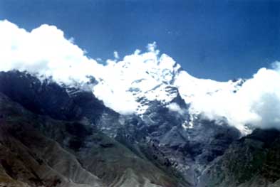
Tomur
Peak of 7453 meters above sea level, means ˇ°Iron Mountainˇ±
in Uighur language. 80.1ˇăE and 42.0ˇăN, it is situated in
the north of Wensu County in the South part of Xinjiang
China and proves to be the highest peak in Tian Shan Mountains
while the Tian Shan Mountains, 2500 kilometers leighth from
the east to the west, tranverses the whole of Kazakstan
and stretches to the centre of Xinjiang China. With 15 high
peaks over 6000 meters and 5 over 6800 meter around it,
Tomur Peak is a place of clustering peaks in the Tian Shan
Mountains. Highly developed, some 509 modern glaciers here
of various kinds total an area of 2746.32 square kilometres
and 350,000,000 cubie meters of water reserve, which serves
as the important water resources in the vast expanse of
both the south and north Tian Shan Mountains.
Deep
in the inland, far away from the oceans, under the strong
effect of the westerly wind in high altitudes and protected
by screens of mountains, the south and the north slopes
differ greatly in climate, while with the humid north slope
and arid south slope, the Tomur Peak area often undergoes
myriads of weather changesin the twinkling of an eye ¨C showers,
a blast of strong wind and occasional hailstones. At an
attitude of over 4500 meters, the temperature remains below
zero all the year round with the lowest of 50 degree below
the zero. Only between the months of July and August can
the temperature rise about 18 degree below the zero, with
proves to be a period of high temperature in a year. A cycles
of 5 or 6 fine days favours a concentrated effort of mountains
climbing.
Five
ridges are on Tomur Peak. They are the West Ridge, the East
Ridge, the Southwest Ridge, the Southeast Ridge and the
North Ridge To the North of the North Ridge is the second
highest peak, Hantengri Peak, which is 6995 meters, at a
straight-line distance of about 20 kilometres away from
Tomur Peak.
With
its top like the spine of a fish, the giant, dangerous and
steep Tomur Peak is covered by uninterrupted snow and often
affected by the harsh climate. Glacier can be found everywhere
in abundance, and the open and hidden crevasses are so deep
as to be immeasurable. The natural barriers of the broken
precipices, the difficulties caused by the crayon, frequent,
snow and ice avalanches and rolling rocks, all pose a serious
threat to the mountaineers.
In
1956, the former Soviet Expedition ascended the summit of
Tomur Peak from the North slope along the northeast wall.
In July, 1977, other 27 Chinese climbers conquered This
peak again from the South slope along the Southeast Ridge.
In 1977, however, the camp site, set up 5800 meters above
sea level by the Chinese Mountaineering Team, was levelled
to the ground by a snow avalanch, but luckily, nobody was
in it. Moreover, in 1986, the Japanese WomanˇŻs Team met
with three snow avalanches in two days. In short, the wild
havoc of snow avalanches constitutes the greatest barrier
for mountaineers.
En
route, Drive up northwards to Wensu county first from Aksu
city. The distance between Aksu and Wensu is about 20 kilometres.
After going up to Taglak, walk northwards
along the Muzart River Valley to the South slope of Tomur
Peak, where the mountaineering base camp may be put up at
one end of the Qongtailan Glacier, measuring 3200 meters
above sea level. Another way to this peak is to advance
for 60 kilometres from Wensu to Pochengzi. After that, trudge
for 40 kilometres northwards along the Muerte River valley
to Gaibieliqi from which you can climb Hantengri Peak and
Snow-lotus Peak. Because it is a difficult mountain, you
should have to consider to spend longer time to do your
attempt-ing to its summit.
Itinerary:
you may have choices which pass, you think, is convenient
to you to enter into China. The following itinerary is only
a kind of suggested one
Day
01 Come
in to China through the Tuogart Pass on the border of China
and Kyrgizstan. Drive further down to Kashgar. Check in
your hotel
Day
02 Keep your driving towards the east to Wensu
via Aksu city. Check in your hotel. The distance is about
520 kilometers by a good highway in this day.
Day
03 A prepare day here. You should have to do your
last checking carefully before going into this mountains.
Day
04 Switch your bus into jeeps and drive till you
arrive at a village named Talak, where your horses and donkeys
will be collected. Camp for night
Day
05/08 Trekking up to the Base Camp with your horses
and donkey along the Muzart River Valley
Day
09 Arrive at Chongtailan, where is used to be the
climbing base camp site. Sept up your base camp.
Day
10/29 Climbing activities
Day 30 Come down to the base camp site
from your altitude camps
Day 31/34 trek down to the village named
Talak. Then say Good Bye to your animal drivers and drive
back to Aksu. Check in your hotel
Day
35 Switch jeeps into a bus and drive Kashgar. Check
in your hotel in Kashgar. The distance between Aksu and
Kshgar is 500 kilometers. It takes 7 ours by driving., good
highway.
Day
36 It should be Sunday today. Sunday is bazaar
day in Kashgar, site of perhaps the largest and longest
running bazaar in Central Asia. As many as 100,000 people
come in from surrounding areas to buy and sell animals and
goods. Early in the morning you can see streams of people
in donkey carts coming in to market. There are separate
areas for animals, furniture, fabric, clothing, shish kebobs,
shaves with a straight razor (including scalp), fruits and
vegetables, and much more. In the animal bazaar care needs
to be exhibited as horses and donkeys are being "test-driven".
Also in the animal bazaar you can find cattle, sheep, goats,
and camels - all in a fairly small, walled-in area. When
you are in the midst of all this, you may feel like you
have stepped back in time several hundred years. After breakfast
you will be free to roam the bazaar or to go along with
a guide who willtranslate Uighur for you.
Day
37 Leave for the Tuogart Pass and exit China, all
the services end in China. ITMC Tien Shan will take a good
care of you when you enter into Kyrgzstan.
|