|
Located
at 87.3ˇăE and 36.4ˇăN, Ulugh Muztagh Peak, at 6973 meters
above sea level, ranks first among the peaks on the East
Kun Lun Mountains and lies in Ruoqiang county of Xinjiang,
China, where the southwest nook of the Altun Wildlife Reservation
and West Tibet have their common boundary.
In
Uighur language, Ulugh means ˇ°greatˇ± and ˇ°Muztaghˇ± means
ˇ°ice mountainˇ±. In the circumference of 200 square kilometers
sit 54 high peaks of 6000 meters above sea level, among
which, Ulugh Muztagh, the main peak, is tied to its sister
peaks, appearing right to be a jade polar holding up against
the sky.
Wrapped
in snow all the year round, Ulugh Muztagh Peak looks up
at the sky and stands upright with the cut precipices. The
long and gentle northwest slope abounds in open and hidden
crevasses while the south slope is 45 degree in gradient.
From here, you can reach the summit by going up the LingLong
river course and assign through three glaciers and a n¨¨v¨¨
Basin. To take both the two routes from the southeast slope
and the northeast slope, you need to negotiate a highland
of 5823 meters in height to arrive right at the summit.
Despite the slope of 60 degree, you may reach the summit
and turn back to the base camp site in one day only if you
avoid the precipices and climb along the uncovered rocks.
With
the highly developed modern glaciers of various types, the
Ulugh Muztagh Peak area possesses 93 glaciers of various
size, totaling 1200 square kilometers, among which the 18-kilometer-long
Binglin Glacier is about 300 meters thick. The giant solid
reservoir formed by the glacier offers the rivers here abundant
water resources. The Qarqan River, the largest of its kind
in Xinjiang, for example, originates from the northwest
ice slope of Ulugh Muztagh Peak. As the result of the violent
movement of the glacier, ice and snow avalanches frequently
occur, cracking soul-stirringly. With the most salient characteristic
of the unpredictable climate, the area of Ulugh Muztagh
Peak is affected by monsoons and westerly wind zone, the
wind of which sometimes reaching force 12 with the lowest
temperature at less than 30 degrees below the zero. The
good mountaineering season is in the five months of June,
July, August,September and October in which July and August
proves to be the best to make longer cycles of five days
available.
As
a result of the fact that the extraordinary geographical
location and that the harsh natural conditions pose difficulties
for getting to the circumference of hundreds of kilometers,
Ulugh Muztagh Peak area still remains in a virgin state
of mystery. Thus, the snowy peak, snowy fields, grassland,
lakes and dozens of precious animals stull live here, all
combine to produce not only the unique natural scenes but
also typically primitive ecosystem and the communities of
living organisms which all remain intact. Ratified by the
State Council, Altun Mountain Natural Reservation, the largest
of its kind in our country, was established in 1983, measuring
an area of 45000 square kilometers. So explorer, mountaineers
and scholars at home and abroad have always been looking
forward to do it. As early as the close of the last 19th
century, some Russians came here to have a survey. Thereafter,
no foot prints had been left over there. It was until 1984
that the Chinese Scientific Exploration Team went twice
into the region
to explore the peak. In 1985, the Allied Mountaineering
Team of China and the United States (with 5 Chinese climbers)
reached the summit along the West slope.
En
route: fly to Qiemo from Urumqi, and drive up to the Tular
Farm. Then keep your moving up to the Southwest and enter
into west part of this Altun Wildlife Reserve. Then you
will see the north slope of Ulugh Muztagh Peak very soon.
It only takes you 5 days by driving from Qiemo town where
located in the south edge of Taklamakan desert.
Itinerary
you may have choices which pass, you think, is convenient
to you to enter into China. The following itinerary is only
a kind of suggested one:
Day 01
Fly to Urumqi from Bishkek,
and check in your hotel
Day 02 Fly to Qiemo by your flight and
check in your hotel in this small town.
Day 03 A free day in this town, do your
last check and preparation
Day 04 You will climb southwards and move
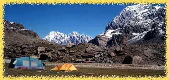
into Kun Lun mountains by jeeps and a supply truck. Find
a good place at your camp site
Day
05 Keep your driving and it is until you arrive
at the Tular Farm. Find a good place by the Qarqa River
for your camp site.
Day
06/07 Climb up to the high altitude area and approach
to Ulugh Muztagh. Camp for night
Day
08 Finally you arrive at the base camp of Mt Ulugh
Muztagh, where located in at foot of the northwest slope.
Set up your base camp
Day
09 this is a relaxing day after long and hard driving
for days. I am sure you will seize the moment to do the
last reorganization for your climbing equipment
Day
10/29 Your time for climbing activities
Day 30 Your jeeps come up again and transfer
you on the way back.
Day 31/33 I am sure it takes you one day
less to reach at Qiemo. Check in your hotel.
Day
34 Fly back to Urumqi. Check in your hotel
Day 35 A tour day
Day 36 Fly to Almaty and catch up your
flight home. All the services endof
this mountain area by the same route but one day less in
the trekking section
|